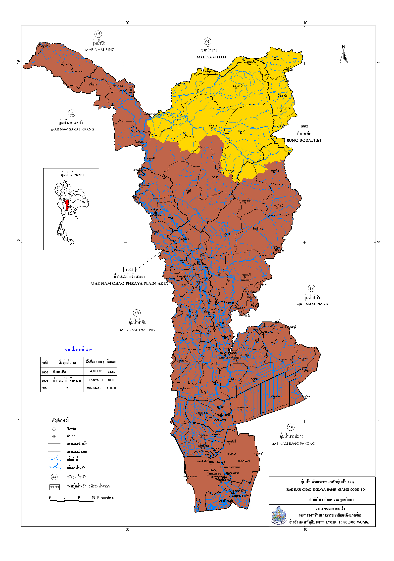
Basic information about the Chao Phraya River Basin.
Area conditions The Chao Phraya River Basin is located in the central part of Thailand, with a total drainage area of 20,266.49 square kilometers. It comprises two sub-basins: the Bueng Boraphet Sub-basin, covering 4,392.36 square kilometers (21.67%), and the Chao Phraya River Plain Sub-basin, covering 15,875.14 square kilometers (21.67%) (Department of Water Resources, 2011). It covers most of the provinces of Nakhon Sawan, Chai Nat, Sing Buri, Ang Thong, Phra Nakhon Si Ayutthaya, Pathum Thani, Nonthaburi, Samut Prakan, and Bangkok. The Chao Phraya River is the main river flowing through it, formed by the confluence of four rivers: the Ping, Wang, Yom, and Nan rivers. The Ping and Wang rivers converge at Ban Tak District, Tak Province, to form the Ping River. The Yom and Nan rivers converge in Chum Saeng District, Nakhon Sawan Province, forming the Nan River. After that, the Ping and Nan rivers merge at Pak Nam Pho, Mueang District, Nakhon Sawan Province, to form the Chao Phraya River. This river flows through Uthai Thani, Chai Nat, Sing Buri, Ang Thong, Phra Nakhon Si Ayutthaya, Pathum Thani, Nonthaburi, and Bangkok before emptying into the Gulf of Thailand at Phra Samut Chedi District, Samut Prakan Province.
Topography The Chao Phraya River basin is oriented in a north-south direction, situated between latitudes 13° 30′ North and 16° 05′ North, and between longitudes 99° 30′ East and 101° 00′ East. Its boundaries are as follows:
To the north, it borders the Ping River basin and the Nan River basin.
To the south, it borders the Gulf of Thailand.
To the east, it borders the Pa Sak River basin and the Bang Pakong River basin.
To the west, it borders the Tha Chin River basin and the Sakae Krang River basin.
The eastern part of the river basin, in its upper section, is a plateau with low hills forming a barrier between the Chao Phraya and Pa Sak river basins. The lower section is a sloping plain descending towards the Chao Phraya River and a coastal plain in Samut Prakan province. The western part of the upper Chao Phraya river basin is a plain, while the lower section is a lowland plain bordering the Tha Chin river basin, sloping down to the coast.
Chao Phraya River Basin